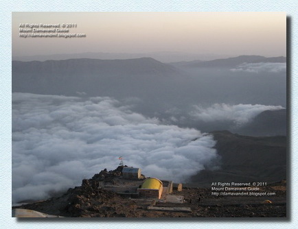
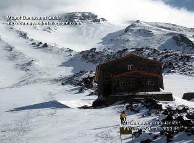
Damavand Map
Mount Damavand Maps
Exploring Mount Damavand: A Trekking Adventure with Road and Route Maps
Mount Damavand, the highest peak in Iran and the highest volcano in Asia, beckons adventurers from around the world to embark on an unforgettable trekking journey. Situated in the Alborz mountain range, this majestic volcano rises 5,671 meters (18,606 feet) above sea level and is a challenging yet rewarding destination for outdoor enthusiasts.
To make the most of your Mount Damavand tour experience, it's essential to have a clear understanding of the road and route maps that will guide you to the summit. Trekking to the summit of Mount Damavand requires careful planning and navigation. To ensure a safe and enjoyable experience, consider the following route maps:
Southern Route (Polur Route): The southern route is the most popular and accessible path to the summit. Here's a simplified overview:
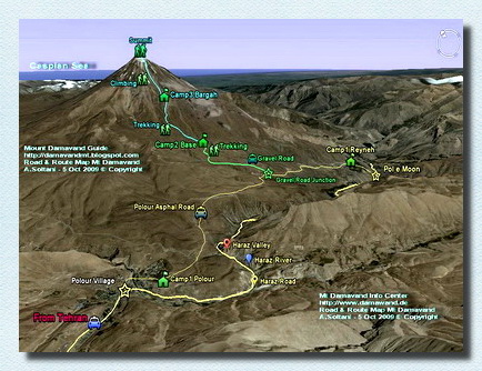
Download and View The Original Size Image
Mt Damavand Iran Road and Route Map
By Ardeshir Soltani, Guide Mount Damavand Iran
Road Map to Mount Damavand Summit
Before you can start your trekking adventure, you'll need to reach the base of Mount Damavand. Tehran, the capital city of Iran, is the most common starting point for travelers. You can fly into Tehran's IKA International Airport from various international destinations. Once in Tehran, you can hire a car or take a bus to reach the village of Polur, which serves as the primary base for Mount Damavand expeditions.Tehran city to Mt. Damavand first Camp Polour Road Map
From Tehran to Polur: The journey from Tehran to Polur is approximately 70-80 kilometers (43-50 miles) and takes around 2 to 3 hours by car from IKA Airport. The route takes you through scenic landscapes, providing a taste of Iran's natural beauty.
Navigating from Tehran city to Mount Damavand Camp 1 in Polour is an exciting journey through Iran's picturesque landscapes. The road map outlines the route, guiding you from the bustling urban heart of Tehran to the tranquil foothills of the mighty Damavand. As you follow the map, you'll witness the transition from cityscapes to pristine natural beauty, setting the stage for your mountain expedition. It's a path that promises adventure and awe-inspiring scenery, making your way to Camp 1 a memorable part of your Mount Damavand tour experience.
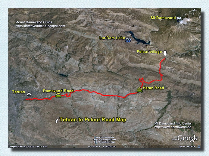
Download and View The Original Size Image
Tehran To Polour Village Road Map
Mount Damavand Climbing Tour
Polur, Your Trekking Base: Polur is the gateway to Mount Damavand. Here, you can arrange accommodations, acquire permits, and hire experienced local guides and mules to assist you on your trek.
Located in the Mazandaran Province of Iran, Polur Mountaineering Campsite serves as the ideal launchpad for your Mount Damavand Trekking tour Guide and Damavand ski touring adventures. This charming town boasts a range of accommodation options, from cozy guesthouses to well-equipped lodges, ensuring you're well-rested before embarking on your trek.
Securing the necessary permits is a breeze in Polur, with local authorities readily available to assist. The knowledgeable Damavand's guides are indispensable companions, offering insights into the mountain's terrain and its rich history. For those with heavy gear, mules can be hired at C2 to lighten the load.
Set against the breathtaking backdrop of the Alborz Mountains, Polur is more than just a logistical hub – it's the starting point for an unforgettable journey up Iran's highest peak, Mount Damavand.
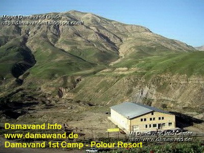
Mount Damavand Camp 1 - Polour Resort
Mt, Damavand Trekking Tour
Photo Damavand Info
Damavand Camp 1 to Camp 2 Road Map
The route from Mount Damavand Camp 1 Polour to Camp 2 is accessible via a gravel road, making it suitable for car travel during the summer months. In winter, adventurous souls can opt for a challenging trek or even a thrilling ski expedition along this scenic path, showcasing Damavand's diverse allure.Mount Damavand Camp 2, also known as Goosfand-Sara, is sometimes referred to as "Mt. Damavand base camp", "Saheb al-Zaman Mosque" or the sheepfold!
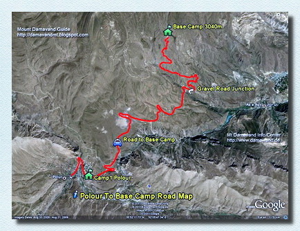
Download and View The Original Size Image
Damavand Camp1 to Camp2 Road and Route Map
Drive the Gravel Road by car in summer or walk/ski in winter
Base Camp (Gosfandsara): Begin your journey from Gosfandsara, a campsite located at an altitude of around 3,000 meters (9,842 feet). This is where you may acclimatize and prepare for the ascent.
Mount Damavand camp II or Base camp - Goosfand-Sara is a starting point for summer treks. It's at 3040 meters above sea level. Here, you'll find a small shelter, a mosque called Saheb Zaman, and a place for sheep.
During the climbing season, tough vehicles like 4WD Jeeps and Land Rovers take climbers and gear to this camp. You can get some water, food, and drinks here, but it's better to bring your own. You might also hire a mule and porter to carry your stuff to the last camp, called Camp 3 or Bargah Sevom.
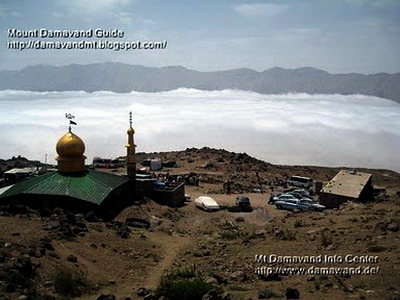
Mount Damavand Camp 2 - BaseCamp or Goosfand-Sara
Mount Damavand Hiking Tours
Photo Damavand Info
Damavand Camp 2 to Camp 3 Map
Track Camp2 Base to Camp3 Bargah Sevom Old Shelter and the New Hut.During the summer on Mount Damavand's south route, your trek begin at Damavand Camp 2. This spot is accessible by off-road vehicles like Jeeps, Land Rovers, and small trucks.
Once you're at the second camp, it's a good idea to start your trek promptly. Walk slowly and steadily for about 4 to 5 hours to reach the Damavand Camp III called Bargah Sevom. Follow the trail, especially if the weather is clear, and you'll easily find your way.
Starting your trek in the morning gives you enough time to reach Camp 3 at 4220 meters above sea level. Here, you can spend the rest of the day acclimatizing. You can stay overnight in tent, the shelter, or the new hut at Camp 3.
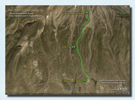
Download and View The Original Size Image
Damavand Camp2 to Camp3 Route Map
Trekking Mount Damavand Iran
Mount Damavand Camp 3 - Bargah Sevom
Damavand Camp 3, Bargah Sevom, is the last stop on the southern route up Mount Damavand. Here, you'll find an old shelter and a new hut built in 2009 by the Iran Mountain Federation, and flat areas for tents. The new hut is more popular than the old shelter because it's newer and nicer.
The old refuge is the oldest camp on Mount Damavand. It gets really crowded in the summer, so it's better to bring your own tent for privacy. Or, you can book a private room in the new hut, which has been serving climbers since 2009 and offers accommodations.
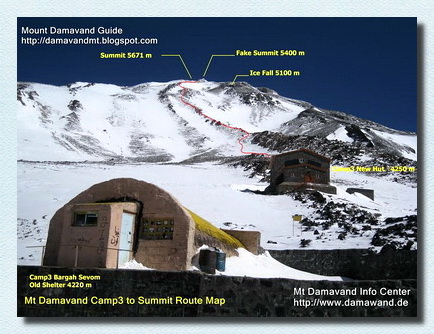
Damavand Camp 3 Bargah Sevom New Hut: The final camp before the summit is Bargah Sevom, situated at an altitude of 4,250 meters (13,950 feet). From here, you'll make your summit push.
Mount Damavand Camp 3 to Summit Map
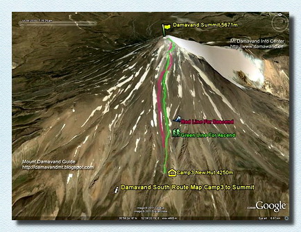
From Old Shelter/Refuge or the New Hut to the peak.Green foot path is for ascend and the red trail is suitable for descend.
The south route up Mount Damavand offers a moderate climb with no technical difficulties, but you must be physically fit to attempt it. Depending on your fitness level, it takes 5 to 7 hours to reach the top. For the descent, consider the Scree Trail, also known as Shen-Ski Trail in Farsi, for a quicker route. You can reach Camp 3 from the summit in about 3 hours using this trail.
Download and View The Original Size Image
Damavand Camp3 Bargah Sevom to the Summit Route Map
Green line for ascend from Old Shelter or New Hut to the top
Red line for descend or ski from Mt Damavand peak to Camp3
Map By Ardeshir Soltani
Mount Damavand Camp3 to Summit Map
Download and View The Original Size Image
Mt Damavand Camp3 Shelter/New Hut to Summit Route Map
Photo By Ardeshir Soltani, Mount Damavand Guide
Summit: The Damavand summit is reached after a challenging ascent from Bargah Sevom. Be prepared for cold temperatures and thin air at the top.
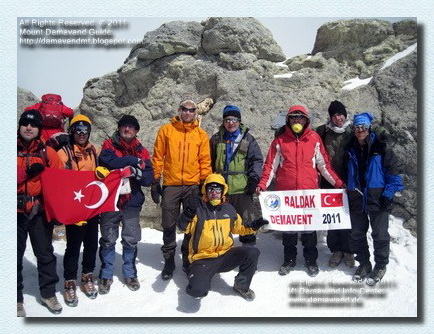
Mount Damavand Summit
Mount Damavand Group Tours
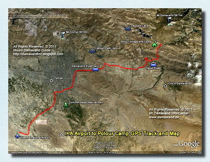
IKA Airport Tehran to Mount Damavand Camp 1 Road Map
The road map from IKA Airport Tehran to Mount Damavand Camp 1 in Polour provides a clear route for travelers. It guides you through the scenic journey from Tehran's international airport to the base camp, offering a convenient path to start your Mount Damavand adventure.
Download and View The Original Size Image
IKA Airport Tehran to Damawand Camp1 Polour Road Map
Damavand Mountain Ski Touring
Mt Damawand in Alborz Mountain Range
Mount Damavand, situated in the Alborz Mountain Range of Iran, stands as a majestic natural wonder and an iconic symbol of the country. This dormant volcano is the tallest peak in the Middle East and a cherished destination for trekkers and mountaineers. With its snow-capped summit and rugged beauty, Damavand's towering presence in the Alborz Range offers both challenge and awe-inspiring vistas, making it a coveted destination for those seeking adventure and the splendor of Iran's mountainous landscapes.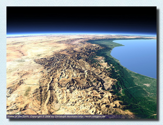
Download and View The Original Size Image
Mt Damawand in Alborz Mountain Range
By Views of the Earth, Damavand Volcano, Iran
Mount Damavand trekking tour
A Mount Damavand trekking tour promises an unforgettable adventure in the heart of Iran's natural beauty. While the journey can be physically demanding, the rewards are immeasurable. With the aid of road maps to reach Polur and route maps to navigate the mountain, you'll be well-prepared to conquer the towering heights of Mount Damavand. Remember to plan your trip carefully, acclimatize properly, and respect the local environment and culture for a truly enriching experience on this magnificent volcano.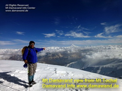
Climbing Damavand Mountain, Iran
winter view from Mt Tochal Peak
Photo Damavand-Info
Damavand-Info
Recognized as the leading agency for mountain climbing tours, Damavand-Info specializes in providing secure and unforgettable guided treks and ski touring on Mount Damavand. Leveraging our extensive experience, we tailor each adventure to your individual skill level, whether you’re an expert climber or a novice hiker. Our knowledgeable local guides are prepared to offer the support needed to summit Iran’s highest peak. We offer a range of activities including hiking, trekking, skiing, and climbing, ensuring an exceptional journey for every explorer.
Mount Damavand: Comprehensive Guide to Iran’s Iconic Peak – Facts, Figures, and More
Mount Damavand, a majestic volcanic peak located in northern Iran, stands as the highest mountain in the Middle East and the tallest volcano in Asia. Rising to an impressive 5,671 meters (18,606 feet) above sea level, this iconic summit attracts climbers, adventurers, and nature enthusiasts from around the globe. Located in the Alborz mountain range, it offers breathtaking views, unique geothermal features, and diverse flora and fauna. This guide covers everything you need to know about Mount Damavand, including its geographical location, climbing routes, weather conditions, and cultural significance. Discover essential tips for trekking, camping, and planning your journey to this extraordinary peak. Whether you’re an experienced climber or a curious traveler, Mount Damavand promises an unforgettable experience amidst nature’s wonders.
Damavand Base Camp
Goosfand Sara Campsite, also known as Damavand Base Camp, is the most accessible and renowned base for Mount Damavand climbs in Iran. Located at an elevation of 3,040 meters, it features a modest mountain refuge, the Saheb al Zaman mosque, and a sheepfold. This camp is the main starting point for summer treks along the southern route, situated at coordinates 35.9020° N and 52.1094° E.
Explore Mount Damavand: Private and Group Mountain Guided Tours & Pakages. Exploring Mount Damavand with a private local mountain guide offers a customized experience that suits your personal preferences. If you prefer a more intimate adventure, having a private guide means you can set your own pace, choose your routes, and receive tailored attention throughout your trek. For those who enjoy the camaraderie of group travel, certified Iranian local mountain guides also offer group tours. These group tours provide the chance to meet like-minded adventurers while benefiting from the expertise of local guides who ensure the safety and enjoyment of everyone involved. Whether you choose a private guide or join a group, you’ll have the confidence that the highest standards of guidance and support are provided.
Damavand Hiking Tours
Damavand hiking tours are an excellent option for those looking to explore Iran’s tallest mountain without committing to a full summit attempt. These tours are perfect for nature lovers, offering guided adventure tours that take you through scenic trails around the base of Mount Damavand. Whether you’re looking for a leisurely trek or a more challenging hike, there are plenty of options available in these affordable tour packages. You can enjoy the beauty of the surrounding landscapes while experiencing the diverse flora and fauna unique to the area, ensuring a rewarding outdoor experience for all.
